5th MAY 2015 - PAPUA NEW GUINEA EARTHQUAKE SPARKS WITH TSUNAMI
SYDNEY - A powerful earthquake rattled the South Pacific island nation of Papua New Guinea on Tuesday, and officials warned that a local tsunami was possible.
The 7.4-magnitude quake struck about 80 miles south of the town of Kokopo in northeastern Papua New Guinea, at a depth of 40 miles, the U.S. Geological Surveyreported, downgrading its original estimate that the quake was magnitude 7.5 and 6 miles deep.
The Pacific Tsunami Warning Center said tsunami waves of up to 3 feet were possible within 186 miles of the epicenter.
There were no immediate reports of waves being seen and no reports of damage, said Chris McKee, assistant director Geophysical Observatory in the capital, Port Moresby.
"The earthquake is offshore and the nearby land areas are fairly sparsely populated," McKee said.
The National Disaster Center also had not received any reports of damage, said acting director Martin Mose.
"We're just sending a message now to the area for villages along the coast to take extra precautions in case a tsunami is generated," he said.
Tuesday's quake was centered in the same area as two earthquakes that rocked Papua New Guinea last week. Neither of those quakes caused damage or generated a tsunami, but they were slightly lower in strength than Tuesday's.
Papua New Guinea sits on the Ring of Fire, the arc of seismic faults around the Pacific Ocean where earthquakes are common.
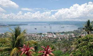 |
Rabaul and Simpson Harbour on New Britain. Photograph: Diana Plater/AAPn |
SYDNEY (AP) — A powerful earthquake rattled the South Pacific island nation of Papua New Guinea on Tuesday, generating a small tsunami near the epicenter, bringing down power lines and cracking walls, but causing no widespread damage.
A tsunami estimated at under 1 meter (3 feet) was seen in the harbor of Rabaul, a town near the epicenter of the 7.5-magnitude quake, said Chris McKee, assistant director of the Geophysical Observatory in the capital, Port Moresby. There were no reports of flooding, as the tsunami didn't rise beyond the normal level of high tide, McKee said.
The temblor struck at a depth of 42 kilometers (26 miles), about 130 kilometers (80 miles) south of the town of Kokopo in northeastern Papua New Guinea, the U.S. Geological Survey reported, after issuing varying estimates of the quake's power.
The earthquake brought down power lines in the Rabaul area, knocking out power to residents and to the local Geophysical Observatory office, McKee said. There were a few reports of structural damage in Kokopo, including cracks in some walls, but no reports of injuries, he said.
The Pacific Tsunami Warning Center said that tsunami waves of up to 1 meter (3 feet) were possible within 300 kilometers (186 miles) of the epicenter, but lifted the warning a few hours later. Apart from Rabaul, there were no other reports of unusual wave activity, and any further threat was likely to be minimal, with waves of less than 0.3 meters (1 foot) predicted, McKee said.
Tuesday's quake was centered in the same area as two earthquakes that rocked Papua New Guinea last week. The nation sits on the Ring of Fire, the arc of seismic faults around the Pacific Ocean where earthquakes are common.
Copyright 2015 The Associated Press. All rights reserved. This material may not be published, broadcast, rewritten or redistributed.
-
papua new guinea earthquake साठी अधिक प्रतिमा
Papua New Guinea earthquake sparks tsunami warning, but ...
www.theguardian.com/.../tsunami-warn... या पानाचे भाषांतर करा1 दिवसापूर्वी - A powerful earthquake rattled the South Pacific island nation of Papua New Guinea on Tuesday, generating a small tsunami near the epicenter, ...7.4 quake, aftershocks hit Papua New Guinea prompting ...
rt.com/news/255581-papua-guinea-eart... या पानाचे भाषांतर करा1 दिवसापूर्वी - A strong 7.4-magnitude earthquake struck the southern coast of Papua New Guinea, US Geological Survey reported. A tsunami warning was ...7.4 earthquake hits Papua New Guinea - Stuff.co.nz
www.stuff.co.nz/.../74magnitude-earthq... - या पानाचे भाषांतर करा1 दिवसापूर्वी - An earthquake measuring magnitude 7.4 struck 139 kilometres south of Kokopo in Papua New Guinea.Magnitude 7.4 quake rocks Papua New Guinea - KING5.com
www.king5.com/story/news/...quake...papua-new-guinea/26905759/1 दिवसापूर्वी - powerful earthquake rattled the South Pacific island nation of Papua New Guinea on Tuesday, and officials warned that a local tsunami was ...Breaking news on Papua New Guinea - breakingnews.com
www.breakingnews.com/.../papua-new-... या पानाचे भाषांतर कराPapua New Guinea is one of the most culturally diverse countries in the world. ... Magnitude 6.8 earthquake strikes of Papua New Guinea; no tsunami expect - ...Small tsunami seen after Papua New Guinea quake
www.usatoday.com/story/news/.../papua-new-guinea-quake/26906263/1 दिवसापूर्वी - SYDNEY (AP) — A powerful earthquake rattled the South Pacific island nation of Papua New Guinea on Tuesday, generating a small tsunami ...Magnitude 7.4 Quake Hits Off PNG, Triggers Tsunami Threat ...
www.bloomberg.com/news/.../tsunami-... या पानाचे भाषांतर करा1 दिवसापूर्वी - A magnitude 7.4 earthquake struck off Papua New Guinea on Tuesday, triggering a tsunami threat for coastal communities. The quake hit 133 ...Earthquake strikes Papua New Guinea, triggers tsunami fear
www.cbsnews.com/news/earthquake-str... या पानाचे भाषांतर करा1 दिवसापूर्वी - SYDNEY -- A powerful earthquake rattled the South Pacific island nation of Papua New Guinea on Tuesday, and officials warned that a local ...


No comments:
Post a Comment